Lamorinda AVA Petition (pdf version)
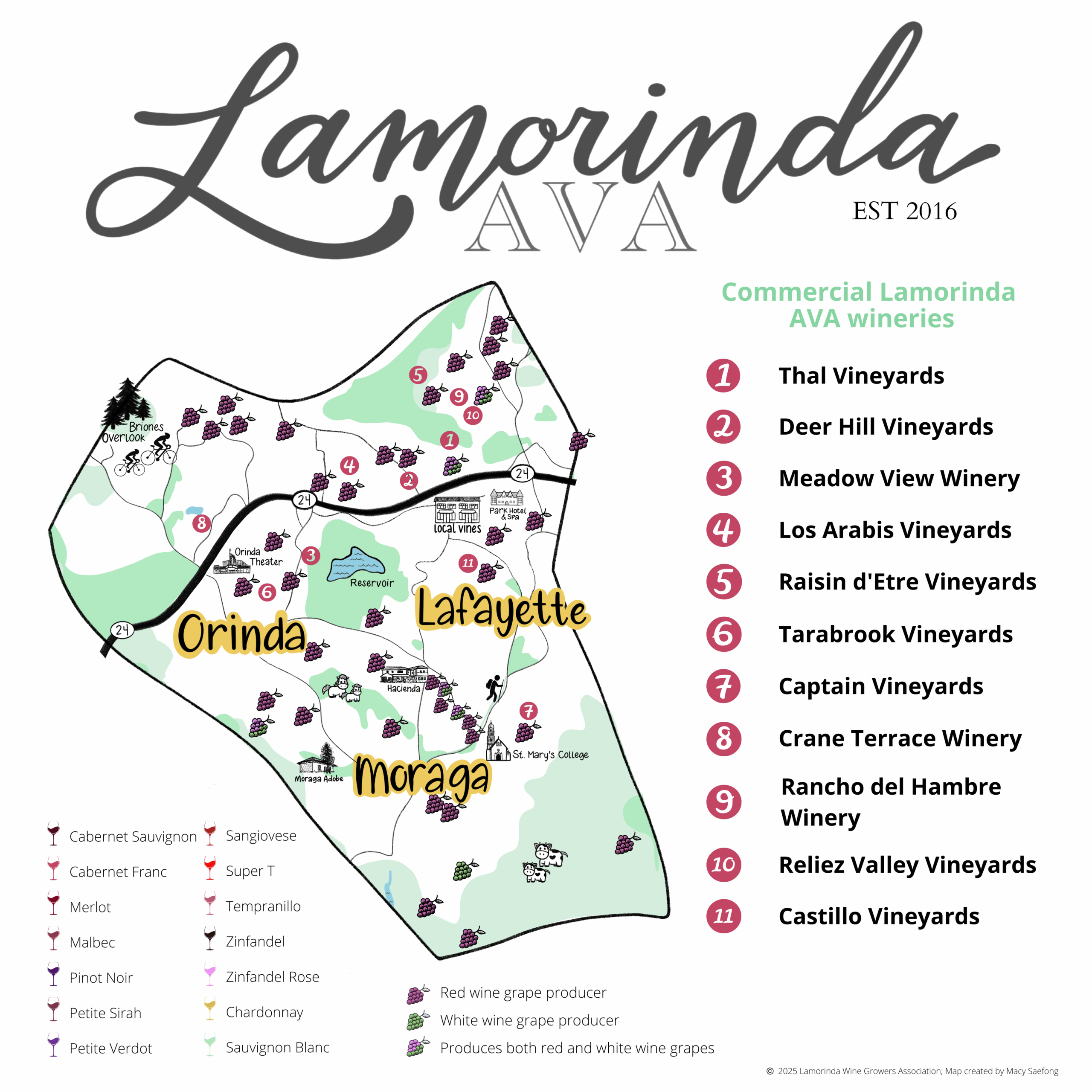
The following petition serves as a formal request for the establishment and recognition of an American Viticultural Area to be named Lamorinda, located in Contra Costa County, California. The proposed AVA covers 29,369 acres and includes nearly 139 acres of planted vines and planned plantings. Approximately 85% of this acreage is occupied or will be occupied by commercial viticulture (46 growers). There are six bonded wineries in the proposed AVA and three additional growers are planning bonded wineries. The large number of growers and relatively limited acreage demonstrates an area characterized by small vineyards, a result of some of the unique characteristics of the area. This petition is being submitted by Patrick L. Shabram on behalf of Lamorinda Wine Growers Association. Wineries and growers that are members of the Lamorinda Wine Growers Association are listed in Exhibit M: Lamorinda Wine Growers Association.
This petition contains all the information required to establish an AVA in accordance with Title 27 Code of Federal Regulations (CFR) part 9.3.
List of unique characteristics:
Table 1 – Distinguishing characteristics of Lamorinda, relative to surrounding areas
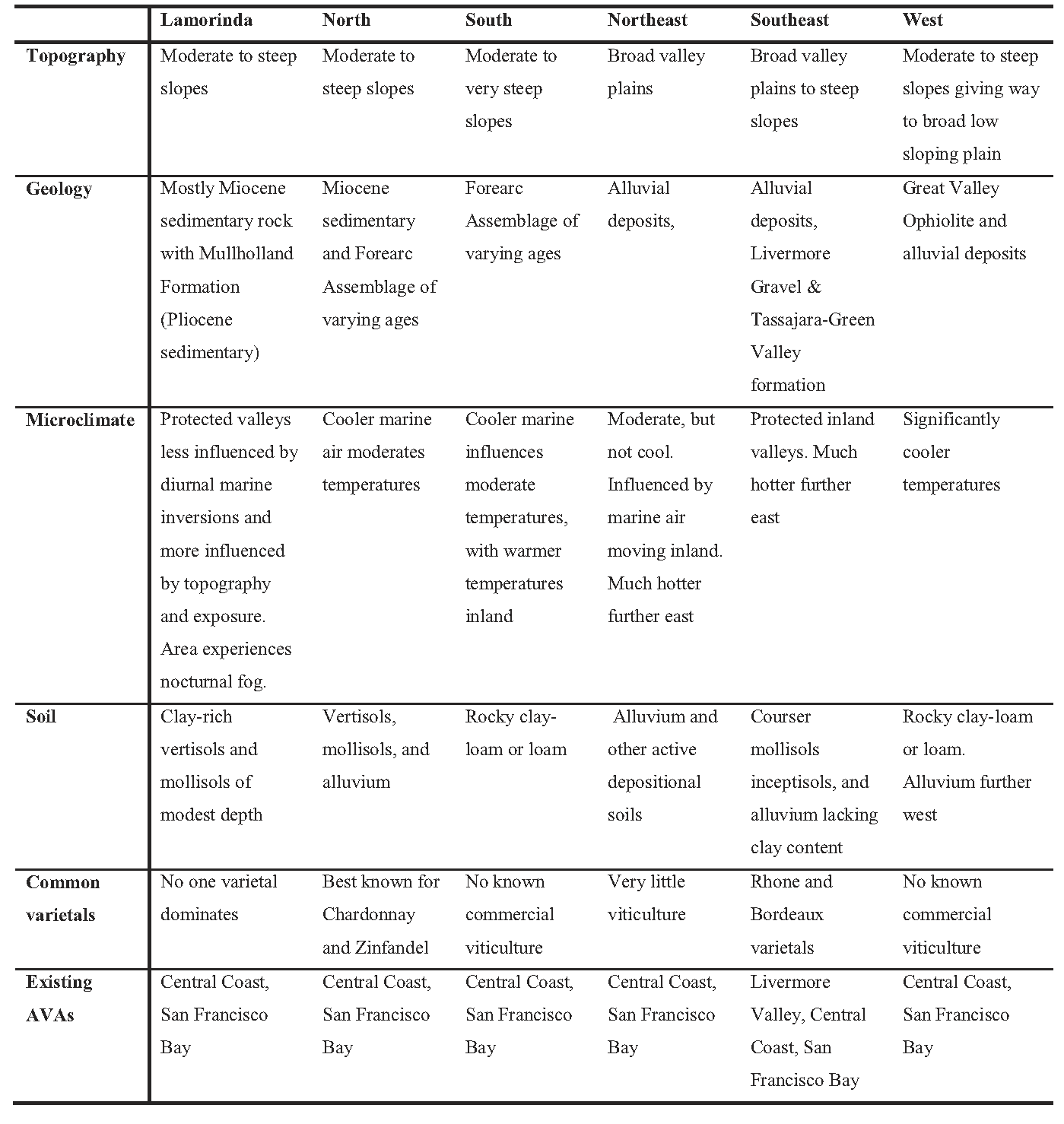
The Lamorinda viticultural area is located in central Contra Costa County, approximately surrounding the cities of Lafayette, Moraga, and Orinda. The area takes its name from a commonly used portmanteau derived from the three city names: “La” (Lafayette), “mor” (Moraga), and “inda” (Orinda). The area occupies the hilly-to-mountainous terrain between the Hayward Fault and Calaveras Fault. The area is unique to coastal California. Viticulture is limited to hilly terrain where local microclimatic conditions are dictated more by terrain than by coastal influence or lack thereof. A unique geologic history has led to younger sedimentary rock, exposed by later uplifting, than what is found in surrounding areas. Soils derived from this rock have a higher clay content. Further, occupying an area that could be describe as suburban, vineyards are limited to small lots, with no one vineyard currently larger than five acres. A twenty acre vineyard is under public review as part of a proposed development to an eighty acre parcel in the city of Moraga, and another thirty acre vineyard in Moraga is currently in the early stages of development.
While Lamorinda is located within Contra Costa County, using the “Contra Costa” appellation of origin is not sufficient to distinguish wine of this area. Most Contra Costa viticulture takes place in east Contra Costa County, an area with no current AVA recognition. Hence, “Contra Costa County” is commonly used by these wineries and the name “Contra Costa County” is typically associated with east Contra County viticulture. The Contra Costa Winegrowers Association, for example, is dominated by east Contra Costa wineries, with no current member from Lamorinda. The climate, topography, and geology are significantly different in east Contra Costa than in Lamorinda, however. Given the small size of the Lamorinda wineries, the vast majority of wines are sold locally. As such, Lamorinda growers and wineries believe it imperative that they distinguish the Lamorinda geography from other Contra Costa County viticulture. Similarly, local industry members know that use of the Central Coast or San Francisco Bay AVAs will not allow local consumers to adequately understand the origin of these wines.
The proposed Lamorinda viticultural area touches, but does not overlap, the Livermore Valley AVA. As is the case with the Livermore Valley AVA, the Lamorinda viticultural area is located entirely within the Central Coast AVA and San Francisco Bay AVA. The proposed Lamorinda AVA does not overlap any other AVA in the area.
In outlining the unique characteristics of the Lamorinda viticultural area, local growers believe Lamorinda is truly unique from surrounding AVAs, including other areas within the Central Coast AVA and San Francisco Bay AVA. Characteristics of Lamorinda, however, continue to be influenced by those characteristics defining the San Francisco Bay AVA and Central Coast AVA. The final rulemaking for the most recent expansion to the San Francisco and Central Coast AVAs, T.D. TTB-48; Re. Notice No. 44 FR 34522, notes “the region east of the Diablo Range and Livermore Valley has higher temperatures, lower humidity, and decreased rainfall.” 1 Lamorinda lies to the west of the Livermore Valley and is therefore not east of the Diablo Range. Further, Lamorinda continues to experience the moderating effects of coastal air out of the San Francisco Bay. Following data demonstrate that Brentwood, a short distance east of the Central Coast AVA and San Francisco Bay AVA has warmer temperatures than Lamorinda. Further, Lamorinda demonstrates temperatures similar to or slightly cooler than Pleasanton, which is located in the Livermore Valley AVA. Hence, Lamorinda experiences conditions consistent with the Central Coast AVA and San Francisco Bay AVA. As such, Lamorinda should continue to be included in the San Francisco Bay AVA and Central Coast AVA. The more specific characteristics of Lamorinda distinguish it from these larger, more generic AVAs. These characteristics include geology, soils, and reduced daytime coastal fog intrusion (but not nighttime fog). Further, the San Francisco Bay AVA and Central Coast AVA include large river valleys, coastal bay flats, and areas of heavy alluvium in addition to hilly terrain, while the proposed Lamorinda AVA is limited to hilly terrain and a specific type of geology. Therefore, Lamorinda is distinguished from other areas within the Central Coast AVA and San Francisco Bay AVA, while maintaining the basic characteristics that define the these two larger AVAs.
The name “Lamorinda” is commonly used in, or by, businesses, sports clubs, publications, map titles, real estate firms, and a host of entities. The name has a Wikipedia page identifying the area as “within Contra Costa County, California in the United States. The name is a portmanteau from the names of the three cities that make up the region: Lafayette, Moraga and Orinda.”2 A competitive youth soccer organization bears the name Lamorinda Soccer Club3 and a competitive youth baseball organization is called Lamorinda Baseball Club.4 A publication serving the area is known as the Lamorinda Weekly, a local, biweekly paper distributed throughout the area.5 Other businesses and organizations include (but are far from limited to) LamorindaMoms, LamorindaWeb, Lamorinda Ruby Football Club, Lamorinda Community Response Team, Lamorinda Democratic Club, Lamorinda Spirit Van, Lamorinda Sunrise Rotary, Lamorinda Music, Lamorinda Pediatrics, Lamorinda Theatre Academy, Lamorinda Solar, etc. Provided as Exhibit N is a Rand McNally map showing the area with the title “Lamorinda.”
The history of commercial wine growing in the Lamorinda area dates back over 150 years. A directory by Ernest P. Peninou, a well-known wine historian, and Sidney S. Greenleaf shows local growers John Grinnell, Daniel Hunsacker, Isaac Hunsaker, and William B. Rodgers collectively had 623 gallons of wine on hand during an 1860 census.6 All growers within this census are listed as “Lafayette and Alamo.” Although the current city of Alamo lies outside the Lamorinda viticultural area, Lafayette clearly had an early association with viticulture. Beginning in 1907, Serafino Rossi grew wine grapes commercially at a site currently occupied by Reliez Valley Vineyards in Lafayette, according to research conducted in the archives of the Lafayette Historical Society.
Based on additional research conducted in the archives of the Moraga Historical Society and Orinda Historical Society, wine grapes were one of many crops grown by early settlers. The Trelut brothers, who settled in Moraga in 1880, planted grapes and made wine on a relatively large scale.7 By 1897, Theodore Wagner was commercially growing grapes in the Orinda area. While some grapes were made into wine locally, most were shipped out of the area, with much of the production apparently sold to immigrant Italians in the North Beach area of San Francisco. None of these early vineyards survive today, although, as mentioned above, there is currently a vineyard and winery on the site of the original Rossi vineyard.
The agricultural focus of the area was gradually replaced by suburban housing development, but a renaissance of small-scale wine grape production began in the late 1970’s. These plantings started with John Alegria, who planted one thousand vines in Moraga in 1978. The number of plantings has accelerated in recent years and led to the founding of the Lamorinda Wine Growers Association in 2005. The first bonded winery, Parkmon Vineyards, was also established in 2005 in Moraga. Today there are almost 139 acres of planted or planned vines across 46 commercial vineyards, and six bonded wineries with 3 planned wineries within the boundaries of the proposed AVA.
A subset of the Diablo Range of the greater Pacific Coast Ranges, Lamorinda has a unique set of circumstances that help define the geographic characteristics of the area. Bound by two strike-slip faults, the area’s geology is unlike geology to the east, west, and south. Meanwhile, the Golden Gate allows coastal influences to move inland into the San Francisco and San Pablo Bays. To the north, the Carquinez Straight filters cooler air into the Suisun Bay. Growing seasonal temperatures further inland warm as marine influences decrease. Hence, Lamorinda, despite being located 23 miles inland from the Pacific Coast, occupies an area of transition from cooler, marine-influenced climates to warmer inland climates. To identify and describe the unique characteristics, Lamorinda Wine Growers Association hired two geologists from the University of California, Davis to study the local geology and soils8 as well as a geographer (and author of this petition) to study and describe the climate of Lamorinda and identify the best boundaries.9 The results of these studies were used extensively in this petition.
Topographic evidence – The Lamorinda area is characterized by hilly-to-mountainous terrain, with a number of moderate-to-steep slopes throughout the region. Valleys tend to be narrow with limited opportunity for large-scale flatland commercial agriculture. All viticulture in Lamorinda is on hillsides. In general, this hilly terrain is bound by the Hayward Fault to the west and the Calaveras Fault to the east. To the north is Suisun Bay and to the south, the Calaveras and Hayward faults nearly merge, creating a wedge-like shape to this mountainous terrain before eventually merging with the Diablo Ranges further to the south. The terrain is significantly flatter west of the Oakland Hills/Berkeley Hills to the San Francisco Bay and San Pablo Bay.
The proposed Lamorinda AVA occupies the heart of this terrain. The Ygnacio Valley and San Ramon Valley to the east present a natural break in terrain and geology, while the flatlands closer to the bays provided a similar distinction to the west). The distinctions are also found in climate, as the microclimatic variations found in this hilly terrain are not prevalent on flatter terrain.
To the south the terrain becomes increasingly mountainous. Rock 2 at the northern extent of Rocky Ridge is at 2024 feet, making it the highest point within the proposed AVA. Terrain along Rocky Ridge southeast of Rock 2 is consistently steeper than terrain found in Lamorinda to the north. West of Rocky Point, terrain drops down into the San Leandro Reservoir, while the Livermore Valley lies to the east of this ridge.
Geologic evidence – According to Dr. Michael Oskin and Dr. Kenneth L. Verosub, who prepared a report on the geology and soils of Lamorinda and surrounding areas (Exhibit B), the Lamorinda area is underlain by unique series of sedimentary rock, attributable to its unique geological history.10 The Orinda conglomeration is the dominant geological formation, which Drs. Oskin and Verosub describe as an unusual deposit of coarse sandstone and claystone casts that were deposited in a terrestrial basin as nearby rocks were uplifted and eroded.” Rock formations immediately adjacent to the Lamorinda area (Oakland-Berkeley Hills to the west, Sunol area to the south, and Mt. Diablo to the east) are derived of older, more resistant rocks formed from sedimentary and volcanic origins. Meanwhile, nearby basins (San Francisco Bay, Sacramento-San Joaquin delta, and Livermore Valley floor) are areas of active deposition.
The Orinda area was once an isolated marine basin fragmented from a broader marine basin by faulting associated with the San Andreas Fault system.11 Older sedimentary rock material deposited in the larger basin and rock derived from sediment ranging from fine grain shale rocks to course sandstones can be found at Mt. Diablo and the Oakland Hills west of Lamorinda. Lamorinda sediment material is younger, however, formed from later sediment that was later folded and upturned by diastrophic tension.
Geological formations include the Orinda Formation, Briones Formation, and Mullholland Formation, with pockets of the Monterey Formation, Siesta Formation, and Moraga Formation. Immediately west of Lamorinda, Forearc Assemblage, Franciscan Formation, and Great Valley Ophiolite dominate along with Moraga Formation and Siesta Formation. Further west, alluvial material is most present. To the north, Briones Formation shares dominance with the Monterey Formation, eventually giving way to Forearc Assemblage. To the east, alluvial material as well as the Livermore Gravel and Tassajara-Green Valley formation is most present, with some Briones Formation at the foot of Mt. Diablo. Forearc Assemblage dominates the Diablo Range, while Mt. Diablo itself is dominated by Franciscan Formation and Great Valley Ophiolite. To the south, Briones Formation, Orinda Formation, and Mullholland Formation continue to dominate, eventually giving way to Forearc Assemblage. Hence, the formations most in line with the Lamorinda area, an area dominated by Miocene and Pliocene sedimentary rock in the Briones, Orinda, and Mullholland formations with pockets of Monterey, Siesta, and Moraga Formations, occupies a northwest-southeast running strip from San Pablo Bay southeast to approximately the Dublin Grade.
The Orinda formation, which is exposed only in Lamorinda, is key to Lamorinda geology, as it formed first and underlies much of the other formations in the area. The formation of a restricted marine basin, caused by the uplift of the Berkeley Hills, allowed for the deposition of fine materials out of the Berkeley Hills and into this narrow basin, creating the Orinda formation. Eventually, this basin became completely separated from the ocean, creating a shallow lake from which the Mullholland formation was created.12
Rocks associated with these formations include shale (Monterey and Mullholland), claystone (Monterey), fossil-rich sandstone (Briones), sandstone (Mullholland), non-marine sandstone and claystone (Orinda), and conglomerate mixed with basalt (Siesta). As noted later in this petition, the composition and how easily the rock is weathered plays a major role in soil development, especially the claystone cast that plays a major role in the development of Lamorinda soils. The soils, in turn, directly affect viticulture in the area. Further, the geologic makeup plays a major role in the topography, which in turns affects soils, slope, and microclimates.
Climatic evidence – Weather data from 2007 to 2011 was reviewed at eight weather stations in and around Lamorinda. The stations used were known to be reliable sources. Four of these weather stations are part of the California Irrigation Management Information System (CIMIS). Four additional weather stations belong to the East Bay Municipal Utility District (EBMUD) and are located at local reservoirs. Data from each station was carefully analyzed to determine the reliability of both the data and the location of the station and any data deemed unreliable or incomplete were excluded from the final analysis.
Exhibit D identifies the relative location of these weather stations. The Brentwood station is in east Contra Costa County (locally known as East County) and is well inland from the Lamorinda area, but was selected to represent temperatures further inland where another active viticulture area currently exists.
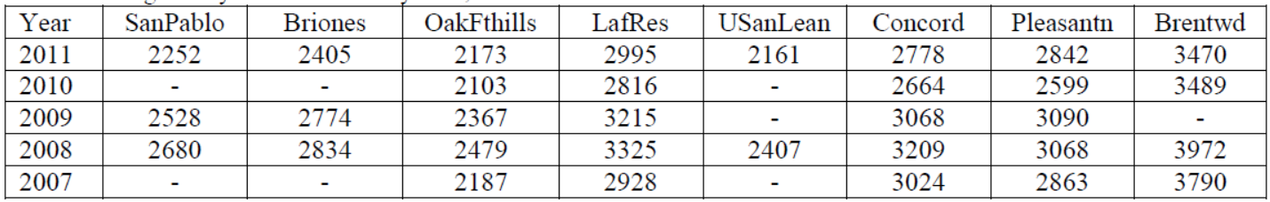
Table 2 lists degree day heat accumulations, utilizing the Winkler/Amerine methodology for calculating heat summations developed by researchers A.J. Winkler and M.A. Amerine.13 Heat summations are much higher at Brentwood (Brentwd), Pleasanton (Pleasantn), and Lafayette Reservoir (LafRes), with lower totals on the peripheral of the Lamorinda area to the north, west, and south.
Table 2 – Degree Day Accumulations by Year, in and around the Lamorinda Viticultural Area
The area displays a high-level microclimatic variation, a result of both topography and the presence of San Francisco Bay, San Pablo Bay, and Suisun Bay. As such, year to year variations in climate may vary greatly based on wind patterns and their influence on marine inversion. By looking at longer term averages, certain patterns appear. Table 3 outlines theses averages based on years were data is available. Maps found in Exhibit C demonstrate the distribution of these averages.
Table 3 – 2-year, 3-year, 4-year, and 5-year Degree Day Averages in and around Lamorinda.
![]()
A review of these numbers and relative locations establishes several patterns. First, Brentwood’s inland location makes it significantly warmer than any of the other weather stations. Marine inversions are significantly reduced, leading to warmer temperatures. Hence, central Contra Costa viticulture demonstrates significant climatic differences from East County viticulture. Second, the Oakland Foothills (OakFthills) and USanLean stations represent the coolest temperatures. Both of these locations are more exposed to marine influences moving from San Francisco Bay into the Oakland Hills and up through the Castro Valley. Finally, Lafayette Reservoir, located in what is typically considered the heart of the Lamorinda viticultural area, represents warmer temperatures, with cooler temperatures to the north and west.
A review of the local topography offers an explanation for Lafayette Reservoir’s warmer temperatures. Several ridges lines, including Franklin Ridge and the Briones Hills to the north and the Berkeley Hills, Oakland Hills and Gunde Ridge to the west, filter cool marine air into this hilly terrain described in this petition. Marine influences entering into the Lamorinda area are limited to several valleys and wind gaps. These include the air moving from the south up from Castro Valley through the Upper San Leandro Reservoir, air moving from the west through the Oakland Hills and over the Moraga wind gap, air from the northwest out of San Pablo Bay through the San Pablo Creek Valley, and air from the north from Suisun Bay up Walnut Creek and Las Trampas Creek into Lafayette. This last point of access is the least influenced by marine air as it is well inland of the Pacific Ocean coast with the Carquinez Straight between San Pablo Bay and Suisun Bay filtering intruding marine air. The weather station at Lafayette Reservoir is located in an area most removed from these separate access points. While the area is subject to nocturnal fog layers, morning fog quickly evaporates and diurnal fog intrusions are not strong enough in this protected area to dramatically lower solar radiation.
A review of high and low temperatures further demonstrates these characteristics.14 As coastal influences are moderated by temperature inversions associated with invading marine air, lower high temperatures are found at areas with the greatest inflow. Graph 1 demonstrates average high temperatures for 2008.
Graph 1 – 2008 Average High Temperatures for the Weather Stations in and around Lamorinda (°F)
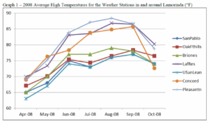
Graph 1, displaying data from 2008, demonstrates that the stations most removed from the various water outlets to the Pacific Ocean are the warmer locations. Concord is the exception. Yet, despite Concord’s location off Suisun Bay, Concord is well inland of the Pacific Coast, the source of the greatest marine inversion layers.
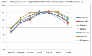
Average low temperatures are much more consistent throughout the region than average high temperatures, with slightly lower temperatures on average found at Pleasanton (Graph 2). These temperatures are subject to a fog layer that commonly moves inland over the entire area. Of the weather stations, Pleasanton is the most removed from a major body of water; hence it is also furthest from nighttime fog sources, possibly explaining the slightly lower temperatures. While diurnal fog has a dramatic cooling effect, nocturnal fog has a modest warming affect. Hence, the key to regional temperature variations really resides in high temperatures, which are dictated by the influence of diurnal marine inversion layers invading the areas.
Graph 2 – 2008 Average Low Temperatures for the Weather Stations in and around Lamorinda (°F)
Graph 3 – 2011 Average High Temperatures for the Weather Stations in and around Lamorinda (°F)
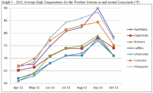
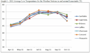
A comparative look at 2011 average high temperatures – the only other year that a complete set of growing season temperatures was available – reveals a similar pattern with the highest temperatures found at Lafayette Reservoir, Pleasanton, and Concord, and the lowest average high temperatures found at San Pablo and Upper San Leandro Reservoir (Graph 3). Meanwhile, Pleasanton shows the lowest low temperatures in the early and late season, but is consistent with the other stations throughout most of the growing season (Graph 4).
Graph 4 – 2011 Average Low Temperatures for the Weather Stations in and around Lamorinda (°F)
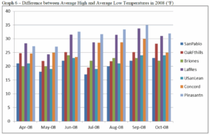
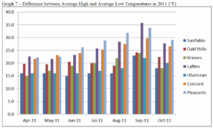
When looking at the difference between average high and average low temperatures, Pleasanton, Lafayette Reservoir, and Concord demonstrate the greatest swings, while San Pablo Reservoir and Upper San Leandro Reservoir show the lowest, a result of the moderating effects of marine air (Graphs 6 & 7).
Graph 6 – Difference between Average High and Average Low Temperatures in 2008 (°F)
Graph 7 – Difference between Average High and Average Low Temperatures in 2011 (°F)
Hence, the role of marine air, other than moderating overall high temperatures relative to inland locations, does not play the same kind of role in Lamorinda as it does in other transitional climatic areas. In other words, Lamorinda, while subject to nocturnal fog, is not subject to the summertime diurnal coastal fog and marine inversions that are common in other coastal transition zones, such as the Sonoma Valley, Dry Creek Valley, or Yountville AVAs. The protected pocket that is Lamorinda receives fuller days of sunlight, or at least as much as permitted by the topography. Lamorinda is generally warmer than the surrounding terrain, thanks to position protected from daytime marine inversions, but not as warm as inland locations where even nocturnal coastal fog is uncommon. Hence, viticulture in Lamorinda benefits from solar radiation and temperatures that allow for long days of photosynthesis when topography permits, allowing full ripening in slower maturing grapes. As noted below, topography also allows for microclimatic variation that will permit cooler temperatures and lower photosynthesis in very localized spots, which in turn allows for the success of slower maturing grapes.
The Role of Topography – While marine inversions and coastal fog do not play a major role in diurnal temperatures, the local topography does. The climate of Lamorinda was analyzed using data from weather stations well positioned to represent a generalization of climatic variation, but the steep-to-moderately steep topography throughout the area creates great diversity from vineyard to vineyard, and even within vineyards. All viticulture is hillside vineyards. As such, viticulture in Lamorinda depends more on exposure and air drainage than the role intrusions of coastal air may play. Both the vegetation present and some of the successful viticulture show that lower elevations within narrow valleys offer cooler temperatures as a result of air drainage and reduced solar radiation. North facing slopes also experience slightly cooler temperatures, while south facing slopes receive greater diurnal/nocturnal variation. These characteristics play an important role in both determining what varietal is most appropriate, when grapes should be harvested, and what kind of stress is being placed on the vine to allow for an intensity of flavor.
Captain Vineyards in Moraga is representative of this variation. Hosting both warm weather grapes (e.g., Cabernet Sauvignon), cool weather grapes (e.g., Pinot Noir), and grapes found in both environments (e.g., Syrah) within a single vineyard, Captain Vineyards utilizes these subtle shifts in climate by placing the cool weather grapes deeper in a valley and warmer weather grapes at more exposed locations on the adjacent hillside. These variations are found throughout the Lamorinda area, but are less relevant in areas surrounding Lamorinda with more level terrain. Concord, for example, is at the mouth of the broad Ygnacio Valley, while Pleasanton is on the floor of the Livermore Valley.
Growers in Lamorinda have the need to carefully assess exposure and air drainage along with temperature when deciding on varietal, trellis systems, spacing, and row orientation. While many in the industry could argue this to be the case in most wine growing areas, such is especially the case in Lamorinda. No one varietal dominates Lamorinda, and the terrain plays a more important role in determining appropriate viticulture, not just by vineyard, but even within vineyards.
Soil evidence – Soils that formed in Lamorinda are generally clay-rich vertisols and mollisols that are reflective of the clay-rich derived strata underlying the region.15 Because of the steep slopes, soil layers are relatively thin and well drained. The clay content allows water retention, but this is offset by just enough sand content, limited thickness to the soils, and steep slopes leading to rapid runoff. Hence, “Lamorinda is characterized by clay-rich soils of modest thickness and good drainage. The steep slopes and thinness of the soils limits the field capacity and creates conditions favorable for growing wine grapes.”16
Thicker soils are found in the valley bottoms, but are not utilized for viticulture because of their higher field capacity.17 These soils are not suited for commercial wine viticulture as surplus moisture increases the risk of disease and often reduces sugar content. Further, soils with lower field capacity stress the vines just enough to increase flavor intensity in grapes. Hence, the nature of Lamorinda soils further restricts viticulture in the area to moderate-to-moderately steep hillsides.
Lamorinda soils contrast with adjacent areas. Soils in the Livermore basin, an area of active deposition, are different from Lamorinda soils in both mineralogy and physical characteristics.18 Predominantly composed of non-marine material, most of the viticulture that takes place in the Livermore Valley does so on or near the valley floor. Here, recently deposited gravelly loams and conglomerates are well drained because of high porosity and good subsurface drainage. These soils lack the same clay texture as Lamorinda soils, so they lack the water retention found in Lamorinda soils. Hence, soils in Lamorinda and the Livermore Valley both feature low field capacities, but do so for very different reasons.
Soils on the foothills of Mt. Diablo, in the northern part of the Livermore basin, are similar to soils found in Lamorinda, but developed under different circumstances and conditions. According to Drs. Oskin and Verosub, “the geologic units that are now in proximity across [Calaveras and other faults of the San Andreas fault system] faults originated tens of kilometers apart in basins with different geologic properties.”19 In particular, soils in the Mt. Diablo foothills are not as clay-rich as Lamorinda soils that developed with the influence of claystone casts that make up the Orinda conglomeration.
Finally, other surrounding areas include soils on steep ridges formed from older, more resistant sedimentary and volcanic rock. These areas include the Oakland-Berkeley Hills, Mt. Diablo, and the Sunol area. Other soils are formed from active sedimentation. These include soils in and around the San Francisco Bay and San Pablo Bay, the Sacramento-San Joaquin Delta, and the Ygnacio Valley. Soils in these surrounding areas are either deeper, coarser alluvial deposits with different moisture characteristics than Lamorinda soils or are fine-grained bay mud, which is unsuited for viticulture.
Suburban landscape – While not typically considered as part of a petition for an AVA, urban morphology cannot be left out when discussing the unique characteristics of Lamorinda. The area is described by many sources as “suburban,” “bedroom communities” and even “upscale suburban.” Wikipedia, for example, hosts this description: “Each city is distinct from the other, but the three share many similar characteristics as suburban bedroom communities with little industry.”20 These suburban characteristics apply not just to part of the AVA, but most of the AVA falls within Lafayette, Moraga, or Orinda city limits. A total of 79.5% falls within the city limits of one of these three cities, which collectively account for close to 60,000 people, a population density of over two people per acre. Another 0.5% falls within the city limits of Walnut Creek. So while any suburban landscape within an existing AVA may be incidental and an exception to the general landscape, such landscape is the rule with Lamorinda.
While most would call Lamorinda suburban or even semi-suburban, local residents prefer the term “semi-rural.” The mission statement for the City of Lafayette, for example, states, “Lafayette was incorporated for the preservation and enhancement of the semi-rural community.” While definitely suburban in nature, the area holds certain rural characteristics, although on a much smaller scale. This semi-rural character is possible because of the nature of the plot sizes leading to lower population densities than what is commonly found in suburban areas. Many homes are built on large lots or include some amount of acreage. The large lots sizes are likely a result of the hilly terrain, which makes subdividing land into 5,000 to 10,000 square foot lots that are common to other nearby communities impossible in Lamorinda. While “semi-rural” may help characterize the larger lots, many of which could be described as “ranchettes,” this area is not an agricultural area. Outside of the viticulture present and a modest number of livestock held more for hobby than for primary source of income, very little agriculture exists. Viticulture is really the only commercial agriculture practiced with enough frequency to be considered an industry in this area.
The suburban landscape of Lamorinda is viticulturally important for a couple of reasons. First, all vineyards are small. All vineyards here occupy excess property of the grower’s private residence. Most are no more than a few acres in size, with the average size vineyard currently 1.4 acres and no existing vineyard larger than five acres.21 Second, the size of the vineyards combined with the hilly terrain means that none of the vineyards are machine harvested. All harvesting and pruning is done by hand. The small size of the acreage also means small production by all growers and a greater diversity in grape varietals, a result of both microclimates caused by the topography and varied approaches to utilizing these microclimates by different growers. Finally, the close proximity of housing to grape production often limits the nature of pesticides and other applications to the vines. 21 This average does not include planned vineyards, three of which are larger than any existing vineyard, This number also does not include vineyards smaller than one half-acre.
The very fact that a description of the urban morphology is necessary in describing the Lamorinda area helps set this viticultural area apart. This distinction applies not only in distinguishing Lamorinda from surrounding areas, much of which is more urban, but from viticulture throughout the country. Viticulture in areas like the Livermore Valley may have some housing that has encroached on rural areas, but vineyards tend to be dozens of acres in size, limiting housing to the periphery of agricultural land. Viticulture also is primarily focused on the outskirts of cities. In Lamorinda, viticulture, which was once common to the area, has encroached back into this well-established suburban area. It is most commonly located within the cities themselves, with vines existing amongst the housing of the area.
The following boundary descriptions approximate the unique geography of the Lamorinda wine growing region. The boundaries are dictated first by topography and geology, including only those areas within the steep-to-moderate slopes west of Walnut Creek and east of Oakland. Second, the area excludes the Berkeley-Oakland Hills, which are geologically different from Lamorinda. The boundaries are further refined to include those sections of the area least influenced by marine air. Finally, the boundaries are limited by steep terrain to the southeast, using Rock 2 as the southern post point, but excluding additional steep terrain to the south. As such, the boundaries were drawn to approximate the local highland areas protected from daytime coastal fog intrusions in and around the communities of Lafayette, Orinda, and Moraga. These areas are home both to the geologic and soil characteristics that distinguish the central Contra Costa highlands, but also experience less diurnal coastal fog influence.
This boundary follows points found on the following quadrangles of USGS 7.5′ Series topographic maps:
Boundary Descriptions
1) The beginning point is on the Walnut Creek map at the water tank south of Grayson Creek and north of Hump 2 in the Canada del Hambre y Las Bolsas land grant. From the beginning point, proceed south-southeasterly 0.8 mile to Hump 2 (833 feet); then,
2) Proceed southeasterly 1.7 miles to an unnamed hill of 781 feet just inside the Lafayette city limits; then
3) Proceed southeasterly 0.3 mile to an unnamed hill of 610 feet; then
4) Proceed south-southwesterly 1.7 miles to an unidentified benchmark, Section 33, T1N, R2W; then
5) Proceed southeasterly 0.5 mile onto the Las Trampas Quadrangle, California map, then another 0.9 miles to the substation, Section 4, T1S, R2W; then
6) Proceed southeasterly 2.3 miles to the summit of Las Trampas Peak (1827 feet), Section 22, T1S, R2W; then
7) Proceed south-southeasterly 2.1 miles to the benchmark Rock 2 2024 feet, Section 26 T1S, R2W; then
8) Proceed west southwesterly 2.7 miles to an unnamed peak of 1057 feet, Section 29, T1S, R2W; then
9) Proceed west-southwesterly 2.0 miles to the eastern intersection of the 1000 foot elevation line with the Contra Costa County/Alameda County line in Section 31, T1S, R2W; then
10) Proceed westerly 0.4 mile to the Oakland East Quadrangle, then another 0.1 mile to an unnamed peak of 1121 feet, Section 30, T1S, R2W; then
11) Proceed northwesterly 3.6 miles to an unnamed peak of 1301 feet, Section 15, T1S, R3W; then
12) Proceed northwesterly 1.6 miles to an unnamed peak of 1634 feet, Section 9, T1S, R3W; then
13) Proceed northwesterly 2.2 miles to the communication tower on the Contra Costa County – Alameda County boundary, Section 5, T1S, R3W; then
14) Proceed northerly 0.1 mile to the Briones Valley map, then another 0.6 mile to Vollmer Peak (1905 feet), El Sobrante land grant, T1N, R3W; then
15) Proceed north-northeasterly 3.0 miles to an unnamed peak of 1027 feet, Del Pinole land grant, T1N, R3W; then,
16) Proceed east-southeasterly 1.2 miles to an unnamed peak of 1130 feet, Del Pinole land grant, T1N, R3W; then,
17) Proceed east 2.1 mile easterly along the Orinda city boundary (Orinda Corp Bdy) to the water tank at 1142 feet, Del Pinole land grant, T1N, R3W; then,
18) Proceed east-northeasterly 1.2 miles to benchmark Russell 1357 feet, Del Pinole land grant, T1N, R3W; then,
19) Proceed northeasterly 0.8 mile to an unnamed peak of 1405 feet, Del Pinole land grant, T1N, R3W; then,
20) Proceed east northeasterly 0.5 mile to the Walnut Creek map, then 1.1 mile to the starting point.
Prior to proceeding with a petition to create the Lamorinda AVA, the Lamorinda Wine Growers Association hired geologists Kenneth L. Verosub, Ph.D. and Michael Oskin, Ph.D. to do an analysis of the soils and geology of Lamorinda and the surrounding areas. Prof. Verosub is Distinguished Professor in the Geology Department at the University of California, Davis. He is particularly interested in the interface between geologic processes and human activity, including the relationship between soils and wine. Prof. Verosub has organized two international conferences on terroir and recently studied soil and geology at vineyards in France, Italy, South Africa, and Chile. Michael Oskin, Ph.D. is an Associate Professor of Geology at the University of California, Davis. He is an expert on faulting and landscape evolution associated with tectonic plate margins. Dr. Oskin also is a member of the science planning committee of the Southern California Earthquake Center and the steering committee for the National Center for Airborne Laser Mapping. The report by Drs. Verosub and Oskin is included as Exhibit B.
The Lamorinda Wine Growers Association also hired Patrick L. Shabram, the author of this petition, to do a climatic assessment of the Lamorinda area (Exhibit C), establish proposed boundaries, and summarize the contents of the different reports pertaining to Lamorinda (Exhibit H). Patrick Shabram is a member of the geography faculty at Front Range Community College and is a geographer specializing in viticulture analysis. Much of the text of this petition is taken from the Shabram and Oskin/Verosub reports. The report also includes photographs taken in the area as well an additional map.
As part of the Shabram analyses, Mike Bobbitt & Associates was hired to create several maps including boundary maps and maps plotting weather stations. Mike Bobbitt & Associates is a Sonoma-based geographic information systems (GIS) company specializing in the wine industry. Maps created by Mike Bobbit & Associates, revised to account for boundary modifications, are included as Exhibits D, E, I, J and K.
Other maps and photographs have been included, identified, and explained below.
Exhibits
Following are a list of exhibits supporting this petition:
Exhibit A – USGS maps outlining the proposed Lamorinda AVA boundary. REMOVED – REPETITIVE
Exhibit B – Oskin, Michael and Verosub, Kenneth L., “Report on the Geology and Soils of Lamorinda and Surrounding Areas,” 2012.
Exhibit C – Shabram, Patrick L., “Climatic Analysis of the Lamorinda Area,” 2012.
Exhibit D – Mike Bobbitt & Associates and Shabram, Patrick L., “Weather Stations – Lamorinda Climate Review,” map, 2012. This map shows the locations of weather stations analyzed for the Lamorinda climate review.
Exhibit E – Mike Bobbitt & Associates and Shabram, Patrick L., “Weather Stations – Lamorinda Climate Review,” map, 2012. This map shows the locations of weather stations analyzed for the Lamorinda climate review, placed over an aerial image of the area.
Exhibit Fa-i – Photographs taken by Patrick L. Shabram demonstrating the nature of viticulture in Lamorinda. Exhibits Fa through Fi were taken of various vineyards located throughout the Lamorinda area demonstrating the nature of Lamorinda Viticulture. Note all vineyards are located on a slope and all vineyards are interspersed with or near housing.
Exhibit G – Photograph taken by Patrick L. Shabram of Moraga. This photo was taken from just west of Captain Vineyards and Winery. Note the low density housing and hilly terrain throughout the area.
Exhibit H – Shabram, Patrick L., “Overview of the Unique Characteristics of the Proposed Lamorinda AVA,” 2013.
Exhibit I – Mike Bobbitt & Associates and Shabram, Patrick L., “Proposed Lamorinda AVA: Aerial Imagery,” map, 2012.
Exhibit J – Mike Bobbitt & Associates and Shabram, Patrick L., “Proposed Lamorinda AVA: Shaded Relief,” map, 2012.
Exhibit K– Mike Bobbitt & Associates and Shabram, Patrick L., “Proposed Lamorinda AVA: Shaded Relief with City Limits,” map, 2012. This map shows the city limits of Contra Costa County cities relative to the proposed Lamorinda boundary.
Exhibit L – Mike Bobbitt & Associates and Shabram, Patrick L., “Proposed Lamorinda AVA: USGS Topo Map,” map, 2012. Note the areas indicated as urban within the Lamorinda AVA interspersed with non-urban ridgelines and narrow valleys.
Exhibit M: Lamorinda Wine Growers Association Membership – A list of current members of the Lamorinda Wine Growers Associations. REMOVED – PRIVACY
Exhibit N: Lamorinda Map – A sample map of a Rand McNally wall map, 2010. The title of this map is “Lamorinda.” REMOVED – REPETITIVE
Exhibit O – Climate charts for the weather stations referenced in this petition for the 2010 and 2009 growing seasons.
Appendix P – Mike Bobbitt & Associates and Shabram, Patrick L., “Proposed Lamorinda AVA: Proximity to the Livermore Valley AVA,” map 2013.
Appendix Q – Mike Bobbitt & Associates and Shabram, Patrick L., “Proposed Lamorinda AVA: Other AVAs,” map, 2013. This maps shows the position of the proposed Lamorinda AVA relative select nearby AVAs.